soul searching road trip oznz – day 11 (16/06/2010)

» soul searching road trip oznz – day 1 (06/06/2010)
» soul searching road trip oznz – day 2 (07/06/2010)
» soul searching road trip oznz – day 3 (08/06/2010)
» soul searching road trip oznz – day 4 (09/06/2010)
» soul searching road trip oznz – day 5 (10/06/2010)
» soul searching road trip oznz – day 6 (11/06/2010)
» soul searching road trip oznz – day 7 (12/06/2010)
» soul searching road trip oznz – day 8 (13/06/2010)
» soul searching road trip oznz – day 9 (14/06/2010)
» soul searching road trip oznz – day 10 (15/06/2010)

i woke up quite early that morning, the night before, i had already told them that come what may, the next morning i would go out hiking at franz josef glacier, which we missed the day before. they all agreed that none of them would follow my trip as they much needed the rest and would only be ready to depart as soon as i got back from the hike. as i left the hostel, it was still dark, the time was 7:30 am and alone, I drove slowly towards the glacier. it was a short distance, the carpark is not more than 4km from the town and my car was the only one there. by looking at the track signs, i decided to follow the path towards peters pool to have my first glimpse of the glacial terminus. it was an enlightening experience, walking alone, in the dense podocarp forest track, and at dawn, with the first hint of light shining through the leaves that took me almost 20 minutes to reach the pool. reaching the kettle lake, the views were magnificent, what with the semi frozen pool, supported by chirping morning birds and i stood there alone, near the pond’s edge, gazing at the terminal face of franz josef glacier and it felt like forever. i took out my cigarette, lighted it and inhale the smokes as slow as possible while absorbing the views and the soundless atmosphere, saved by the cries made by the local inhabitants. i tried to sit on a wooden bench after some time, but finding it too cold, i returned to my original position, standing up and looking at the serendipitously remarkable mountains, gradually lighted by the rising winter sun.
▼ first! peters pool

▼▼▼ sunrise at franz josef glacier


to follow the same path which will wind up next to the glacier would take me more than an hour to reach and my time was precious. therefore i left the place and walked towards the carpark and reentered the westland national park which comprises of other glaciers and reserved forests along the west coast through another track, the sentinel rock track, which promises to have a better and closer view of the terminus but requires a bit of steady climb. the sign was accurately true and it steadily ascends for 30 minutes before reaching the wooden viewing platform where i thoroughly sit on the wooden steps for 5 minutes, out of breath and almost passed out. but the view from the platform was rewarding enough that as soon as i stood looking towards the glacier, i was re energized by the whole panorama and i began to take pictures earnestly.
▼ dark mysterious trail or the open one?

▼ picking the dark trail, sentinel rock walk

▼ glacier face from sentinel rock walk

later, while descending the track, i met other travellers who came by to see what i just saw. reaching the carpark, i restarted the car engine and revved up back towards the hostel where the others were almost ready to depart for our journey. zack and the rests took turns in pulling the bags and the kids and zack went to yha hostel for one last time to check out. before we left franz josef town for good, we stopped at the town fuel station to fill up and zack also bought me an extra large power bar for breakfast. i ate my breakfast while driving northbound along sh6 with the morning mists set in.
▼ yha franz josef glacier

less than 15 km past franz josef, another road signage for a scenic stop came to welcome us and i duly parked the car on the left side of the road. i got out leaving them behind and what awaited there was another spectacular view of lake mapourika with a mirror view lake and a distant enveloping mist. i walked towards the jetty and more postcard like view was captured. i spent a brief moment marveling at the sight and later got back inside the car and moved on. the whole trip on the west coast was quite uneventful as we passed small towns and villages without taking a break, the fresh landscape was slowly corrupted by the gloomy clouds and i had to scrap my initial plan of detouring 50 km inland towards hokitika gorge because of the weather. after a long stretch skirting along the beach, we reached hokitika town without stopping as everybody was fast asleep and we still had to cross the southern alps again eastbound.
▼ calm lake mapourika

after crossing hokitika river and leaving the town, we left sh6 at kumara junction and entered sh73. the road winded through hills along taramakau river when i stopped for a smoke at otira, there the landscape becomes mountainous again and we started seeing snow again. the clouds cleared and became azure blue. by the time everybody was awake, i continued the journey climbing uphill and we entered arthurs pass national park. it was dry tussock land all over again, except this time, unlike the previous days, the snow was not in abundance. i careened the car carefully while traversing the mountains and i stopped once as the temptation was too much to handle and snapped a few photos. the road began to descend a bit until we met the picturesque lake pearson where i had to park and let the passengers roamed free and stretched their legs in the process. it was to be our last pretty lake on the whole trip. later, our views of the mountains was dotted by rocky boulders and we knew perfectly well that this place must be the location for those chasing of urukhais in lotr the two towers. If we had more time, i surely would have stopped and explored those rocks but a quick stop was enough at castle hill. the snow got thinner, we continued our drive and the road finally settled and we were back on the plains of canterbury.
▼ a quick cigarette break near otira

▼ arthur’s pass national park

▼▼▼ alif, yomi and companion #3 at lake pearson


▼ castle hill

the time was almost 2:15 am and i speeded up a bit and we passed the town of springfield, stopped in front of four square at darfield for lunch takeaways. darfield was the epicentre of the january 2011 earthquake, the precursor for the devastating february 2011 earthquake. an hour later, we rejoined sh1 that we left a few days earlier and the car slowly cruising back towards christchurch. entering the city during daytime was quite different and the scenery and buildings were amazing. i took the same route and finally arrived at dorset house around 3:30 pm. most of us went inside to use the toilets and picked up our room key for the night. we loved it so much when we were there that we decided to have another night there. dorset house is also currently closed until 2012 for repairs in the aftermath of the february 2011 earthquake. zack requested them to ring up a taxi service to take the six of us to the city centre. about 15 minutes later, an mpv arrived on the doorstep and took us on a 10 minutes ride along hagley park and dropped us at christchurch cathedral square for a price.
▼ our favourite backpackers hostel, dorset house

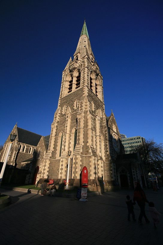
the square was largish, filled by ancient and new buildings alike but created a uniformity in tone and design. the most prominent christchurch cathedral stood vigorously with its anthemic tower and spire, surrounded both sides by the war memorial on the right (north) and the chalice sculpture on the left (south). sadly the tower collapsed 8 months later during the february 2011 earthquake and we were really grateful in being able to see it then. zack and ija went to a fish and chips stall in the square and bought some for the rest of us our late lunch. the kids were excited to see the trams entering and leaving the square. it was then zack realized that she forgot to return the keys to our room in franz josef and it was still in her rucksack. panic stricken, i comforted her and told her that it was ok as yha also got their own branch somewhere close to where we were at the moment. i dialed yha franz josef and told them that the keys were still with us and they said that we should passed the key to their christchurch branch as their manager was still there and planning to return to franz josef that same evening. they told me that the address is in manchester st., just a few blocks away and by studying the local map, zack went alone to return the keys. we waited on the bench near the cathedral, befriended by the local pigeons for 30 minutes before zack came back all smiling. i knew it went well. it was almost dark by then and they went to buy souvenirs in few remaining open shops near the square and soon we walked back towards dorset house, about 2 km north of the square. it took us 30 minutes.
▼▼ christchurch cathedral


▼ the tram

▼ the war memorial

▼ the chalice sculpture

▼ and finally leaving for good

that night, after taking a hot bath, i went to the kitchen area as zack was cooking dinner. it was spacious, comfortable, warm and we were greeted by the local tenant of dorset house, tipora who showed an interest in hanging out with us. he even sampled zack’s tomyam, omelets and rice and made his favourite hot choc with honey drink for us. i went outside, the temp was closed to freezing point, and phoned diman to reconfirm our eta for the next morning. trembling with cold, i finished my cigarette, got back inside and left zack, ija, aina and tipora and went with the kids to our room and turned off the bed lights. i drove 385 km that day.
next» soul searching road trip oznz – day 12 (17/06/2010)

a pic a day (day 133)

a common sight along the state highway 73 while crossing the main divide of the south island. the clear and serene views of the arthur’s pass national park, finely composed of mountains and tussock grasslands was a parting gift to us after 5 days of travelling and gorging the staggering landscape. june 2010.

the location:

a pic a day (day 129)

the snow covered coronet peak, at 1,649m, is the first commercial skifield in new zealand, accessible through the narrow gorge rd. from queenstown. photo was taken 17 km away from the top of queenstown skyline gondola windy viewing deck facing northeast in june 2010.

the location:

a pic a day (day 119)

while we are still on a church series, christchurch cathedral, located in the centre of the city in cathedral square, is synonymously known as the city itself. pic was taken on a late afternoon in june 2010, approximately 8 months before the devastating february 2011 6.3 magnitude earthquake that completely destroyed the spire and heavily damaged the structure.

the location:

soul searching road trip oznz – day 10 (15/06/2010)

» soul searching road trip oznz – day 1 (06/06/2010)
» soul searching road trip oznz – day 2 (07/06/2010)
» soul searching road trip oznz – day 3 (08/06/2010)
» soul searching road trip oznz – day 4 (09/06/2010)
» soul searching road trip oznz – day 5 (10/06/2010)
» soul searching road trip oznz – day 6 (11/06/2010)
» soul searching road trip oznz – day 7 (12/06/2010)
» soul searching road trip oznz – day 8 (13/06/2010)
» soul searching road trip oznz – day 9 (14/06/2010)

▼ good morning!

that morning we left deco backpackers at 8:30 am and queenstown was a bit cloudy so i didn’t take any photos. the temp was 4°c. we left the town and its suburbs soon after and i kept looking for a fuel station to fill up the tank. i drove through sh6 again but since there was no fuel station in sight, i turned left towards the town of arrowtown, a historic gold mining town where we circumnavigated the town (famous for its well preserved architectural buildings) twice before giving up the fuel station quest and returned back (about 10 km each way) to frankton to refuel. yes the town was nice and everything but at the time i was preoccupied with finding the petrol and we still had a long way to go.

we restarted our journey for the day by entering the crown range road, the highest paved road in new zealand, off from the sh6 going northbound cutting through the cardrona mountains. the uphill road was really narrow and it zigzagged through a steep terrain until there was an opening for me to pull over. the views to the south were engaging to say the least as we had the opportunity to observe the remarkables from the eastern side. then the road climbed steadily until we were again in a snow territory and i had to be extra careful of the narrow and slippery road. there was no side road area for stopping and none of the few cars that we met along the way put on the snow chains so neither did i. when the road reaches the highest point, it gradually descends alongside the cardrona river with the road and the river sandwiched between the crown range on our left and the griffel range on our right and there we took a quick stop at cardrona valley with its famous historical hotel. after continuing downhill for about 40 minutes, we could see a large blue lake right in front of us to reveal that we had arrived at lake wanaka.
▼▼ deco backpackers


▼ zack with cardrona hotel and its old vintage chrysler

when we came to a t-junction that signified the end of the crown range road, i decided to detour our route to the left (westbound) which would bring us to glendhu bay, about 10 km west of wanaka town as during my online research, many travellers favoured the secluded bay that provided serene views of tititea/mt. aspiring and other scenic mountains compared to views from the more famous spot near the town. the small carpark near wanaka track, glendhu bay was totally empty and when i positioned the car and stopped the engine, everybody was asleep. i woke up zack and whispered to her that i wanted to hike up the track just to see what’s on the other side. zack said ok and i left walking slowly through the cold morning track for about 100m before it opened into a wide views of the lake, treble cones and lo and behold, the mighty peak of tititea/mt. aspiring, at 3,033m, the highest mountain in new zealand outside of mt. cook range. i was lucky that day as the giant was known to be quite shy to show its peak by hiding behind clouds.
▼ glendhu bay – wanaka track entrance

while walking back towards the car, i met zack who came alone halfway through the track. i put the dslr on a large boulder near the edge of the lake and we took a rare photo together, with lake wanaka and the treble cones as a backdrop. i also took a photo of zack that i am still proud to this day, not sure why except that i like the way she posed, a beauty surrounded by the beauty of nature, two things i love dearly.
▼ my favourite pic

while returning to the car, both of us could hear the screaming sounds coming from alif and yomi. both of them were crying since waking up a few minutes earlier and found none of us were there while ija and aina were not able to pacify them. during the drive back towards wanaka town, they stopped crying and became fascinated and impressed by the large black cattles grazing on the steep grassy slopes of roy’s peak, 1,581m above sea level. just a few hundred meters before the town, we turned left and entered a gravel road towards the famous roy’s bay, lake wanaka. all of us got out of the car where zack brought alif inside the public toilet for a much needed break (for alif) and ija, aina, yomi and i strolled quietly to the waterfront of lake wanaka with a stretch of pebbly beach, adorned with the scenic tall poplars fringing up the shore. from the southern shore, we could see the snow covered rob roy peak (2,606m), mt. avalanche (2,591m) and the buchanan peaks (1,882m). the weather was crispy clear, the time was 11:00 am and the temp was 5°c. i took some photos of the brilliant landscape all the while observing supposedly some locals jogging with their dogs along the beach.
▼ on the shore of lake wanaka

▼▼ spectacular scenery

20 minutes later, we were back inside our car and moved slowly past wanaka town, another resort town but smaller than and not as famous as its otago counterpart, queenstown. 2.5 km east of the town, still along sh6, i found the large compound for our next stop, the wanaka’s puzzling world. it was one of the few attractions that we were willing to pay some cash to get into. i didn’t go in but let the others enjoy their time and gave the dslr to zack. while they were inside, i just sit in the car, went out a few times for smoking intervals but too cold to stay far too long. about 30 minutes in, i heard a familiar cry from inside the wooden fence separating the car and the maze on the other side. it was yomi’s who got lost and decided to let everybody hear her distress signal. zack gave up taking photos and passed the camera over the fence to me and went to get yomi.
▼ stuart landsborough’s puzzling world

▼▼ illusions room


▼ another misplaced hobbit

when they came out 1 hour later, everybody was talking about what a joy the place was, from the exciting exhibitions, illusions rooms, oddities to the confusing maze. even alif (and maybe yomi) enjoyed it. soon we set out again, going towards the north via sh6. the highway runs along the neck of land between lake wanaka on the left (west) and lake hawea on the right (east). i stopped once for a photo opportunity to capture lake hawea and the surrounding mountains. alif complained again about needing to go to the loo and i started looking for another rest area where i could park the car. we found one, near boundary creek, 35 km north of wanaka town, on the shoreline of the northern end of lake wanaka. while zack tended alif, i brought yomi to the pebbly shore and put her on a boulder while snapping more photos of her with mt. albert, at 2,057m on the other shore across lake wanaka. she looked awkwardly strange because of the coldness i guess (it was 4°c) but i kept chuckling whenever i looked at her pic later on.
▼ lake hawea with corner peak at 1,661m

▼ yomi at lake wanaka and mt. albert

▼ at boundary creek

we continued our trip towards the north on sh6 by passing lake wanaka and the small town of makarora through mt. aspiring national park. the vegetation along the way became drastically more subtropical, native, wet and dense compared to the dry swaths of otago region. we were approaching the west coast region and we needed to cross the southern alps first to get there. while we were in the process, i found a sign showing the track direction to the blue pools of haast pass, a famous scenic azure blue pools that were fed by the melted glacier. i pressed the brake, parked the car and told zack that i wouldn’t be out for long. zack said ok as everybody except her were sleeping. i walked enthusiastically about 20m towards the track entrance and could see the sign more clearly which stated that a one way trip would take 45 minutes, to return back, i needed at least 2 hours and our tight schedule did not permit that. it was already 2:00 pm. feeling kind of sad, i returned quietly to the car, started the engine and moved away from the place. about 30 minutes later, we arrived at another scenic stop, this time it was thunder creek falls of haast river that traverses the southern alps between haast and haast pass. i went out alone again, walked about 100m through a winding track among the lush podocarp jungle. i could hear the sound of water crashing at the bottom of the falls were getting louder but realized soon that it was too far and still the falls was nowhere in sight. again i gave up and walked back to the carpark and resumed my driving.
▼ haast river

▼ thunder creek falls info

driving through haast pass, as it is known, was quite an enjoyable and enthralling experience. it was quite wet, cold and the mountain top was less snowy than the previous mountains we had left behind. we slowly left the mountains and the road started to go downhill along haast river. everybody was quiet and their faces showed a hint of sadness of what they missed on those previous days. we exited the highway and entered haast township for lunch takeaways. the town was small and almost non-existant but we found a decent fish and chip shop where zack and ija went inside to order our lunch. after filling our hungry stomachs, we moved out of the town and re-entered sh6 and crossed haast river near the coast using a one lane road bridge, the longest in new zealand at 737m. i snapped a few pics on the banks of the river, under the bridge after crossing it. then we cruised along the banks of the west coast along the tasman sea where i stopped again for less than 5 minutes to snap more pictures of the blue sea at knights point with its rugged coastline, typical of the west coast region. from then on i didn’t stop at all until we reached fox glacier and our car turned into the narrow road towards the glacier.
▼ getting lunch at haast township

▼ haast bridge over haast river with mark range at background

▼ native trees along the west coast

▼ the tasman sea and arnott point from knights point

the small turnoff lane runs about 2.5 km from sh6 geared towards the glacier, while dimly lit alongside fox river under the tiered canopy of trees. when we arrived at the gravelled carpark, there were few cars from other travellers parked as well. from there we could see the glacier, our first, and had to walk by crisscrossing the river through rocky and moraine paths towards the glacier terminus for 1 km. it looked very close, but after walking for about 30 minutes, the glacier only seemed slightly bigger and much further away. we also greeted other returning travellers whom we met along the way. the two kids were of course on our shoulders again and out of breath, with fox glacier coming into full view, we stopped, (after 50 minutes of tramping on the rocky path), took countless photos and retreated back to our car. reaching our car, the sun was almost set and i drove slowly towards the main highway, going northwards again for 45 km until we entered the town of franz josef glacier where our lodging for the night awaited us. our host for the night, yha hostel was easily found and i let zack did all the registration and even requested for a room upgrade while the rests were still waiting inside the heated car. she got back later with a small map containing direction to the nearest mart. the mart, another four square supermarket, is only next to the highway and zack, ija and aina shopped all the necessary stuff for our dinner.
▼ fox glacier carpark

▼ tramping through the moraine path

▼▼▼ fox glacier terminus


▼ completing the track

▼ almost dark at the carpark

i drove them back to yha, checked in, and let the three of them cooked at the hostel kitchen while i looked after alif and yomi. soon they brought some cooked rice, broccoli tomyam, mushroom & cheese omelette and tuna for our dinner. we ate, the ladies cleaned the dishes, we alternately took baths at the shared toilet and thereafter i went outside for a couple of smokes. the temperature was freezing near 2°c, my nose running with fluids of all kinds, i shakily got back inside the room and after travelling for more than 380 km that day, i finally dozed off.

▲ good night
next» soul searching road trip oznz – day 11 (16/06/2010)